Tibet's Gyirong Border Disaster Grows: Dammed Lake Threatens Rescuers as Missing Count Reaches 558
Three days into the Gyirong border disaster, the official count has risen to three dead and 558 missing on the Chinese side, with a debris-dammed lake forming across the border in Nepal that rescuers now regard as the most dangerous new threat. Beijing has ordered an all-out search, and rescuers with central relief supplies have reached the port.
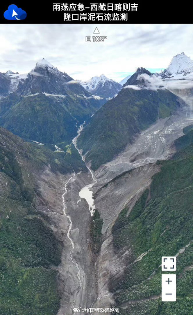
The numbers keep climbing at Tibet's Gyirong Port, and so does the danger. On August 26 a mudslide that began on the Nepal side of the Himalaya swept through the narrow river valley on the Chinese-Nepali border, burying part of the border post under rock and debris. By the evening of August 27, the official toll on the Chinese side stood at three people dead and 558 missing, according to state media, while Nepal has reported its own far higher count of 165 dead and 826 missing.
Earlier this week, the border crossing was cut off almost instantly, with the road, power and communications severed along a roughly three-kilometre stretch of the G216 highway. Chinese transport authorities have been racing to reopen the route, while the Ministry of Industry and Information Technology says it has deployed emergency communications teams to restore a lifeline for rescuers and the communities beyond the port.
The most alarming development now is hydrological. Satellite monitoring has spotted a large debris-formed dam on the Nepal side, near where the Tsojian River empties into the larger Purbur Gyangchu. With three days of monsoon water backing up behind it, officials warn the structure could fail at any moment, releasing a wave of water and debris downstream towards the rescue zone. The Ministry of Water Resources says it is monitoring the lake closely and has already run flood-simulation calculations for what would happen if the dam bursts.
For rescuers, that changes the arithmetic of an operation that was already difficult. The port sits at the bottom of a steep avalanche chute, and the valleys feeding into it are still shedding debris. A first batch of 141 people from the China Search and Rescue team arrived at Gyirong town on the afternoon of August 27 and was continuing towards the port itself, while People's Liberation Army and armed-police units have reportedly sent more than 500 personnel. Helicopters from the Tibet military region have flown over the area to survey the final approach.
The disaster has drawn the highest-level response. State media quoted an instruction from President Xi Jinping urging that no effort be spared in finding the missing and relocating people at risk, while Premier Li Qiang called for accurate casualty figures and careful, scientifically informed rescue work to avoid secondary accidents. Three central government departments have allocated 30,000 pieces of relief supplies.
What makes this disaster so hard to grasp from outside is how routine it is in concentrated form. Every summer, the monsoon pushes moisture against the Himalaya, and the steep valleys running south from Tibet turn into chutes for rock, ice and water. What is different here is the scale: the slide began on the Nepal side and produced enough material to cross an international border and destroy a port that is one of the main trading gateways between China and South Asia. Caixin reported that the border-crossing infrastructure on the Chinese side was buried, which is why so many of the missing were likely at the port when the slide arrived.
In the hours after the disaster, Chinese experts and meteorology enthusiasts began posting satellite comparisons tracing where the slide triggered: high-altitude ice and rock appears to have collapsed in a narrow, glacier-carved channel, sending a wave of slurry down the drainage. That initial pulse was followed by a deeper, slower mass of saturated sediment that is still settling — and that continuously shifting ground is part of what makes reaching the port so slow.
The immediate question for the next 48 hours is the dammed lake across the border. If it fails, it could turn a painstaking search-and-rescue effort into an evacuation. Rescuers are, for now, caught between two clocks: the scale of the missing, and the water building up behind the debris.